Archaeology trail at Luserwasserfall
gemiddeld Themed walks · Haus-Aich-Gössenberg
Tourkenmerken
Conditie
Tourinformatie
Parcours: 2.97 km
Duur: 01:30 h
Beklimming: 262 m
Afdaling: 262 m
Beste jaargetijde
Januari
Februari
Maart
April
Mei
Juni
Juli
Augustus
September
Oktober
November
December
De tour
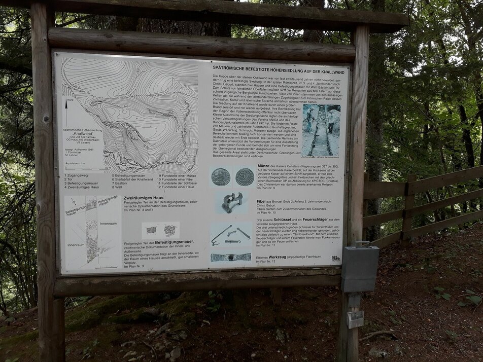
The only archaeology trail in the Enns Valley was opened in 2000 and is maintained by members of ANISA on a voluntary basis. It is a cultural highlight from the late Roman period. Here we can follow a tour through a late Roman retreat settlement. Signposts and explanatory panels tell us about life almost 2,000 years ago. At the beginning of the Migration Period, a refuge castle was built on the Burgstall in Rössing-Ramsau to protect against enemy raids. Excavations have unearthed rich evidence of life in this settlement. Remains of house walls and finds from everyday life provide evidence of a lively settlement in the late Roman period. This listed archaeological site is a 5-minute walk from the “Burgstaller”. The archaeology trail leads hikers up a steeply sloping hilltop to the south. Entry is free (at your own risk) and the site can be visited almost all year round.
Nadere informatie
Routebeschrijving
Our hike starts at the starting point next to the Ramsau/Rössing country road. It is important to pay attention to the yellow signs, which lead us along a field path directly to the Luserbach stream. From there, we continue uphill along this stream to the Luser waterfall. The path leads past the waterfall to the Burgstaller forest road. We follow this forest road to Burgstaller. Shortly before the farmstead, a meadow path leads slightly downhill to the archaeology trail (approx. 5 minutes' walk). We follow the signs along the path - many special boards and signs explain the finds and special features of this Roman settlement. Our return route is the same as the outward route and leads back to the starting point at the Ramsau/Rössing country road.
Start
Leave the provincial highway (B320) at Hauser Kaibling. Continue in the direction of Weißenbach to the village square. Turn left there and continue towards Ramsau - Ramsau/Rössingstraße country road - the dirt road branches off right next to the country road (follow the yellow signs). The parking lot is located a few meters before the entrance to the dirt road.
Arrival by public transport not possible.
Parkeren
Small bulge just before entering the forest street towards Luserwasserfall.
Start
Weißenbach/Rössingstraße
Bestemming
Weißenbach/Rössingstraße
Equipment
good shoes, possibly hiking poles
Tip van de auteur
If you only want to visit the archaeology trail, you can drive to Burgstaller by car. From there it is only a 5-minute walk
Overige informatie en links
Weersvooruitzichten
Datum kiezen
Light snowfall in the early morning, but most of the day will be dry.
Partly sunny in the morning, gradually becoming cloudy in the afternoon.
First cloudy and rain mixed with snow. Then drying up and the clouds might break up towards evening.


