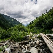
Your Obertal Mountain Time – a 4-day hiking experience
Tour description
A hiking tour over 4 days with 3 overnight stays in mountain huts. The tour is also suitable for families with kids. The duration of daily stages varies between 2.5 and 4 hours.
Your Obertal Mountain Time
The 4-day hike in Obertal valley is a beautiful multiple-day hike for hikers who only want to walk shorter stages and really want to enjoy the time on the trail, at the lakes, and the chalets. Along this route there are several lakes, historic sites, beautiful alps, impressive views, cragged mountains and cosy chalets. Highlights are the picturesque Landauersee lake, Duisitzkarsee lake, the Nickel museum right at the beginning of the tour, or the historic miners‘ settlements at Vetternkar cirque near Giglachseen lakes.
The tour
Map, elevation profile & further information
Getting There
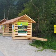
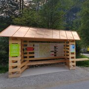
Taking the Planai bus from Schladming (WM-Park Planai or Lendplatz) or Rohrmoos is the best way for getting to the trail head. In case you arrive by car, there are public parking lots at Wehrhofalm in Obertal valley, that can be used for multiple-day parking as well. Via the »Smeltering Furnace Tour« you walk to Hopfriesen in about 30 minutes to the hiking trail head, where the 4-day-hike starts off.
Day 1 | To Giglachseen Lakes
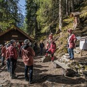
From the hiking trail head in Hopfriesen you follow the historic miners‘ route # 776 towards Giglachseen Lakes. Right at the beginning you can make a 5-minute detour to the historic nickel smelting furnace, which is open as a museum nowadays (open Wednesday and Friday mornings from June throughout September).
From the smelting furnace you hike up a sunken road through clear forest, passing by underneath a steep rock face, where you get a great view back to the valley. A bit further you reach Lackneralm chalet (private only), with nice alpine meadows inviting for a break. You again cross over Giglachbach creek and continue on alternating sections of hiking trail and forest lanes up to the »Knappenkreuz« waypoint cross near Landauersee lake. The cross was erected in honor of the mountain blessing and for mining work in the Giglach cirque. We recommend you make a detour to the picturesque lake (about 45 minutes additional minutes).
From Landauersee Lake you hike back to the main trail and continue towards Giglachseen Lakes. Soon the ascent of the trail gets more flat and you hike through the beautiful Giglachalmen alps. Along the creek you continue your hike, where you pass by the remains of miners‘ housing. Soon you reach the eastern shore of the larger Giglachsee Lake. Now your opportunities for an overnight stay are not far anymore: Ignaz-Mattis-Hütte chalet is situated above the lower, bigger Giglachsee lake, Giglachseehütte chalet lies above the upper, smaller Giglachsee lake.
Day 2 | a promising hike to Duisitzkarsee Lake
The best way to start the second day is to go around the two Giglach lakes (if you didn‘t do that on the first day). Another option is to make a detour (about 1 ½ to 2 hours in addition) to the remains of historical miners‘ dwellings in Vetternkar at the eastern end of the large Giglachsee lake via path # 702. Otherwise you take the hiking trail # 776 to the wayside cross with the hiking trail # 775, where you now continue towards Duisitzkarsee lake.
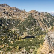
Now you hike slightly uphill from the Giglachkar cirque along the slopes of the Giglachalmspitze and the Murspitzen to the mountain saddle called Murspitzsattel. The wonderful view back into the Giglachkar and down to the Landauersee will let you stop again and again to enjoy the view, and there are some nice places for you to linger too. When you arrive at Murspitzsattel, you have a magnificent view of the natural gem Duisitzkarsee – understandably one of the most photographed mountain lakes in the Schladming-Dachstein region. A good reason for a little rest and extensive enjoyment of the view.
Quite steeply (and at the beginning with a short rope insurance) it goes downhill into the Duisitzkar cirque, the beautiful mountain lake almost always in view. There are two overnight accommodations at the lake: the Fahrlechhütte directly on the lake and the Duisitzkarseehütte a few meters further above. You can relax and unwind around the lake.
Day 3 | In historic realms
After a hearty breakfast on the hut terrace, you start the third day of hiking. On the eastern shore of the Duisitzkarsee lake, follow the signs towards Neualm and Keinprechthütte. Through a fairly sparse forest with lots of larch and stone pine you hike gently up and down to the south – including beautiful views of the valley head of the Obertal valley. After a leisurely 1 ½ hour walk you will reach the alpine pasture area in Neualmkar with a small waterfall and the Neualm chalet (private only). Here you can take a break on the hut terrace or directly by the stream.
After the rest, it now goes up the trail # 774 to the Keinprechthütte. Once you hike up the first terrace in the terrain, there is a magnificent view of the high alpine landscape in Neualmkar, with the Neualmkarbach meandering through the cirque. Along the hiking trail – optionally along the track – you hike steadily uphill to the Keinprechthütte, where you will spend the third night. The mountains around the hut have been the scene of brisk mining activity in the past centuries.
Day 4 | Back to the valley
On the last day, the descent into the valley is waiting for you. Along the hiking trail # 774 you hike to the Eschachalm, where you can stop for coffee and cake. From there you can comfortably take the Planai bus back to the starting point in Hopfriesen or to the Wehrhofalm and of course to Rohrmoos and Schladming. If you want, you can of course also hike out of the valley from Eschachalm and get to the starting point in Hopfriesen (about half an hour). The hiking trail along the Obertalbach further out of the valley to Rohrmoos is also worthwhile.
From Schladming take provincial highway L722 (Rohrmoosstraße road) to Rohrmoos and at the round about continue on provincial highway L723 (Tälerstraße road) to the village of Untertal. In the village turn right on "Obertalstraße" road and continue to Wehrhofalm where you can park your car also for a couple of days. From Wehrhofalm it is a 30-minute-walk along the "Smelting Furnace Tour" to the hiking trail head "Hopfriesen", where the tour starts.
Parking is available at Wehrhofalm in Obertal valley.
Parking is also available at the valley terminal of Gipfelbahn Hochwurzen cable-car in Rohrmoos where you can catch the bus to the trail head.
Taking the Planai bus from Schladming (Planet Planai or Lendplatz) or Rohrmoos is the best way for getting to the trail head.
- Buses of Planai-Hochwurzen-Bahnen: www.planaibus.at
The second day may be a challenge for inexperienced hikers. In the Murspitzsattel area, the hiking trail is exposed to steep terrain. The descent to the Duisitzkarsee is very steep at the beginning and has rope insurance for a distance of about 40 m. Great cautionis required here! The tour is basically also possible with children, but these should already be tried out with hikes lasting several hours.
Changes in weather patterns, quick falls in temperature, thunderstorms, wind, fog and snow are some of the dangers that can be encountered on a hiking tour. Hosts of mountain huts and refuges have a lot of experience in the mountains and can give good advice about weather and trail conditions. Poor equipment, overestimation of one‘s own capabilities, carelessness, poor personal constitution and/or wrong judgement can lead to critical situations. In case of thunderstorms: avoid summits, ridges and steel ropes.
GPS data and orienteering
Available GPS data – just like hiking maps – is only a guidance for orientation and can never depict a trail exactly with all its details. Especially at dangerous spots it is essential to judge on site how to proceed.
In an emergency please call:
Emergency call 140: for Alpine emergencies (all over Austria)
Emergency call 112: European GSM emergency number
Ankle-high hiking boots recommended.
A well-packed backpack is helpful and especially when touring Alpine terrain a tuque, gloves, a windproof jacket and pants are standard equipment. Good, waterproof shoes, hiking poles, sun glasses, sun cream and sufficient beverages are essential too. When hiking for several days, it is important to keep the luggage as compact as possible so that it can be easily carried over several days.
In the area Obertal (from the Eschachalm and in the alpine areas around the Keinsprechthütte, Duisitzkarsee and Neualm) it is not permitted to hike with your dog– out of consideration for the wild animals as well as the alpine and grazing cattle.
If you are one of the toughest ones and go swimming in the lake, be considerate of the fish in the lake and avoid, for example, stirring up dust. In addition, please do not go into the water with sunscreen, as this can upset the sensitive ecology of the lake.
Tourist information: www.schladming.com
Information about bus schedules: www.planaibus.at
360° drone images
Get yourself an overview with our 360° drone images:
- View over Giglachkar cirque: https://vonoben.schladming-dachstein.at/sommer/index.php?S=307
- Giglachseen and Kalkspitzen summits: https://vonoben.schladming-dachstein.at/sommer/index.php?S=308
- Lower Giglachsee Lake and Vetternkar cirque: https://vonoben.schladming-dachstein.at/sommer/index.php?S=309
- Duisitzkarsee Lake: https://vonoben.schladming-dachstein.at/sommer/index.php?S=311
- View into Neualmkar cirque: https://vonoben.schladming-dachstein.at/sommer/index.php?S=312
- The Keinprechthütte: https://vonoben.schladming-dachstein.at/sommer/index.php?S=312&_ga=2.214826590.895318649.1607500567-1860055774.1603178013
- Hiking map ‘Hiking WEST’ available at the information offices in the region.
- Schladming hiking map, 1:25,000, available at the Schladming information office.
- Hiking map Schladming-Dachstein, 1:50,000, available at the information offices in the region.
- Hiking guide Schladming-Dachstein by Herbert Raffalt, available at the information offices in the region.


